Showing posts with label trail. Show all posts
Showing posts with label trail. Show all posts
Tuesday, September 10, 2013


Saturday, June 15, 2013
Coyote Creek Trail
This board caught my eye on the first day to the office... I had to go there and have a glimpse of the creek... :)

To my delight, on a working day, right after I got out of office, we parked our car at the entrance and took the trail... Below is a picture of the entrance area...

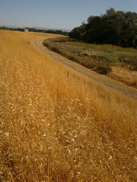
It is a paved trail for hikers and bikers... Lined on either side by these dried grass..

Do these plants really belong to the grass family? I don't really know... But I love the sound of them rustling when the wind blows...


The view of these golden grass plants looks very beautiful even from the MacArthur Blvd.

We walked on the trail for about half an hour in either direction, but there was no creek in view. May be it gets dried up during this time of the year...
Sunday, April 28, 2013
Paseo Padre & yellow flowers
I love the drive to office via Paseo Padre... Until a couple of weeks back, the landscape was full of bright yellow flowers.... spread as far as the eye can see... How I wished to walk by them!

One fine day we did walk by them... Little desires in life... and how happy the soul feels when they get fulfilled... the heart jumps with joy and lives in the state of ecstasy!


I love those yellow flowers... May be they are mustard flowers. I am not sure though!


One fine day we did walk by them... Little desires in life... and how happy the soul feels when they get fulfilled... the heart jumps with joy and lives in the state of ecstasy!

Those three houses reminded me of us, three sisters! Strange how our mind finds connections! This below picture is from the Patterson Ranch road.


But within weeks the whole farmland was ploughed and they were gone! But I will wait for this time next year to enjoy them again! :-)
Monday, March 4, 2013
Trail Challenge 2013
I am proud to say I have signed up for this trail challenge. I hope this will add more exercise to my lazy life.
Click here for more info on the challenge. It's FREE, so sign up if you live close to the Bay area.... and challenge yourself!
Thursday, November 1, 2012
Covered Bridge at Southford Falls
It was a chance visit to this covered bridge. We were on the way to another state park when we passed this bridge and we had to stop by! This is the first covered bridge we visited.

Here is a closer look.

What did it look like from the inside?

What about the view of the falls from the bridge?

How long is the bridge?

What was under the bridge?

What is the name of the bridge and when was it built?

View of the falls from through the windows of the bridge

Tuesday, October 9, 2012
Windiest Place on US Pacific Coast
A 2-hour drive from our place is a National Park that is home to the windiest point on the US Pacific Coast. Actually it is a National Seashore called Point Reyes and the windiest point is at the lighthouse.


The road to the lighthouse is long with changing landscapes all the way.

It is a serpentine road that goes through ranches. We can see cattle here and there.

From the parking lot, the lighthouse visitor center is around a mile's walk away. The trail is on a hill/cliff and passes through a very beautiful landscape. We see the ocean on one side. It's amazing! See how it looks like a painting! No one will believe if I say this photo is real and has not been touched up! :)

The play of sunlight on water... makes it look like a painting!

If you are lucky, you can spot some elk grazing.

We pass by some cypress trees bent to one side due to the winds from the ocean (probably!)

At the end of the trail is the visitor center and the flight of steps leading to the lighthouse. At the starting of the stairs, was a WARNING notice.

This is my first time to reach a lighthouse by climbing down the steps, I have always climbed up the stairs to reach the top of the lighthouse and never had to climb down!

Here is our first glimpse of the lighthouse (Down, extreme right corner)

Here's a better view... But the "light" part of the lighthouse is still obscured from our vision.

Here's the "light"

Finally we reach the last step. Notice the step number 308. It says 308 steps, but the steps are deep. So, actually it is much more than that!

We can also have a look at the actual lens used by the lighthouse.

This lighthouse was in operation from 1870 to 1975. It has withstood winds recorded up to 133 mph.

The current lighthouse (which is in operation) is much further down the cliff closer to the water.

Rain or shine the lights must never be left unattended. The fate of ships on this coast was dependent on these lights.

How did I know that this place is the windiest in the US Pacific coast? There is a little museum at the Visitor center which has a lot of information about Point Reyes and the lighthouse. I got the information from there.

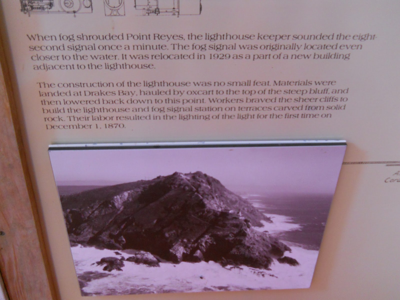
The fog signal was located closer to water. But it was relocated next to lighthouse in 1929.
Being a keeper of the lighthouse may be a very lonely job.
Here are some entries in the log during some bad weather days. Poor souls!

Where exactly is this place? Here's where it is on the map.

You can find more information here
Tuesday, October 2, 2012
Trail Signs
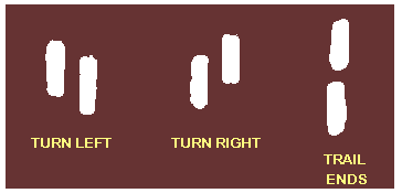
Recently while I was looking for trails in Connecticut area, I came to know the signs used to indicate a trail. It is very interesting.
Click here to visit the webpage
- A trail is marked by 5” vertical lines painted on trees, rocks etc.
- Two parallel vertical lines are used to indicate turns
- If a left line is higher than the right line, it is a left line and vice versa
- A vertical line on top of other marks the end of trail

Click here to visit the webpage
Saturday, September 29, 2012
Alameda Creek Trail
Whenever we travel or visit places, I always think of writing about it... more like maintaining a travelogue... I take photos and think of captions but I never get to actually blog it!
This is my first attempt on blogging it...
Last weekend, we went on a hike on the Alameda Creek Trail.

We parked our car at the Niles Old Canyon Road parking lot.

We did not walk for long! We might have touched the 1.5 mile mark and took a U-turn to where we started.
The trail is paved and has the Alameda creek on one side.

There wasn't much water in the creek and many rocks/pebbles that were supposed to be underwater, were exposed and gleaming in the sun.

The trail is lined with trees on both the sides.

The trail passes under bridges as well. We went under three of them!

While we walked, we saw a couple of fruit-laden trees. Does that look like an orange tree?

Let us get in closer...

No they ain't oranges! I don't even know what trees they were. The color of the fruit/berries were ranging from green to orange to pink.

I could not help spending a lot of time near these trees...

I was taking a lot of pictures of them... I kind-of became obsessed with them... Okay... Okay... I wont bore you more with more of these pictures... Here is a different plant. It looked like a cactus, but the leaves were not that of cactus.

There was date palm tree as well on the bank of the creek.

There was line of eucalyptus trees. Suffering from a blocked nose? Just walk by these trees; Their characteristic smell is sure clear up your nose!

I found another tree with branches growing downwards and swaying in the breeze. Beyond this tree there is a railroad crossing. We touch that point and took a U-turn.

Beyond the creek, we could see the hills, now covered with dried-grass and brown in color.

The hills are lot more beautiful during spring. The grass is green then and the hills look green and full of life.

It was a sunny bright day... And I was walking hand-in-hand with V... Ah! What a fulfilling day it was!

This wont be my last visit... I will surely come back again and again... I may probably try to cover longer distances on the trail!

Subscribe to:
Posts (Atom)